
Flood barriers go up in Ironbridge as county remains on alert
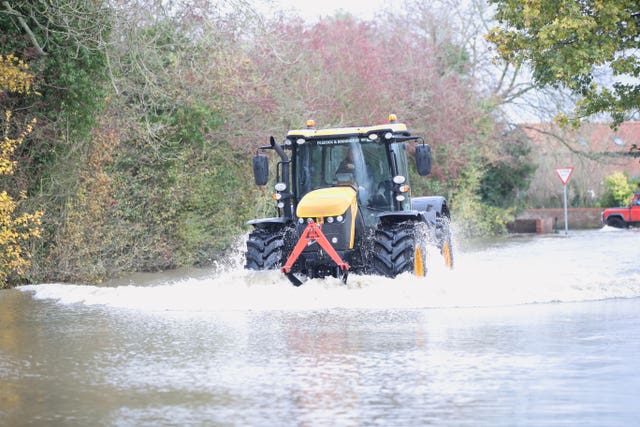
Flood barriers were going up in Ironbridge this afternoon as the recent wet weather continued to effect Shropshire and Mid Wales today, with flood warnings and alerts in place in the region.

The Environment Agency said specialist teams would be out in Ironbridge this afternoon, putting up the temporary flood barriers.
It added: " Local road closures in place. Town very much open for business!"
Former borough councillor Nicola Lowery was on site as the road was closed just after 12 noon and said :”The Wharfage in Ironbridge is now closed to vehicular traffic as the flood barriers are being deployed by Telford & Wrekin Council and the Environment Agency as river levels continue to rise.
“It was a quick response from our teams and I would like to thank all of the officers involved for their hard work in keeping our communities safe”.
Meanwhile, today's weekly Shrewsbury parkrun has been cancelled because of flooding.
Organisers tweeted on Friday: "Sorry, Shrewsbury parkrun is CANCELLED tomorrow, Sat 16th Nov due to river flooding."
At Leintwardine, just over the Shropshire border with Herefordshire the River Teme reached its highest recorded level on Friday morning, exceeding the summer floods of 2007.
The power of the River Teme in flood between Knighton and Leintwardine was captured in this video by Gareth Lloyd.
Mr Lloyd also captured this image of the river at Clungunford.
Firefighters in Presteigne were called to help rescue a motorist who ignored the road closed sign and got stranded in floodwater at Combe Corner.
Flood warnings - meaning flooding is expected and immediate action is required, were today in place for :
River Severn at Ironbridge and Jackfield
River Severn at the Showground and The Quarry, Shrewsbury
River Teme at Stanford Bridge
River Vyrnwy at Maesbrook
River Vyrnwy at Melverley
Live flood alerts counter:
Flood alerts - meaning be prepared, flooding is possible - were in place for:
Lower Teme
River Lugg North of Leominster
River Severn in Shropshire
River Sow and River Penk
Severn Vyrnwy Confluence
Tern and Perry Catchments
The River Dee Catchment in England from Whitchurch to Chester
Upper Teme
Parts of the country could still be affected by flooding through to Tuesday, according to the Environment Agency (EA).
In a forecast of the flooding risk in England and Wales, the EA states: “River flooding is expected to continue in the Lower River Don washlands area in South Yorkshire through to at least Tuesday, where properties will continue to flood and there will be continued travel disruption.”
It comes as 79 flood warnings and 111 flood alerts were still in place in England by Saturday at 11.10am.
The EA states that river flooding is expected for Evesham in Worcestershire on Saturday and residents should be braced for properties to be affected and travel to be disrupted.
It warns that local river flooding is also “possible” in parts of South Yorkshire, Lincolnshire and parts of the Midlands until Monday, and in Oxfordshire on Saturday.
Communities in parts of central and northern England were cleaning up after being overwhelmed with water following torrential rain in recent days.
The Met Office said that most of the southern UK and Scotland is set to stay dry with sunny spells while some heavy showers are expected in the far west of Wales and Cornwall on Saturday.
The EA for Yorkshire and the North East said there was still lots of flood water in the region where a pumping operation is under way to reduce water levels.
In an online message Martin Christmas, of the EA, said: “We are starting to think about moving from emergency rescue response into recovery and that means looking at our flood warnings and then starting to think about all the inspections we need to do to look at potential repairs for banks and flood assets based on the loading they have received from the water in the last week.
“We have still got tens of people out there in the field carrying on with pumping activity trying to get levels at Fishlake reduced and we are also keeping an eye on East Yorkshire as well.”
The Met Office said its Sheffield weather station has recorded its wettest ever autumn.
It stated: “With 15 days still to go, the site has already recorded 427.6 mm of #rain. The previous record was set in 2000 with 425.2 mm of rain falling between September 1 and November 30 that year.”
There is also a “risk of seeing a very cold start” on Tuesday, according to Met Office meteorologist Sophie Yeomans.
She said: “It is still quite chilly this weekend and we will all have some chilly starts. Tuesday will probably be the coldest of the starts.
“For Sunday morning most places will be under the cloud and rain so Wales and northern England will probably be seeing about 5 to 6C overnight.
“Then across southern England where there are clear skies many places will probably drop to a little below zero to minus 1C or minus 2C in countryside areas.
“For Tuesday morning I think probably in England and Wales we could see as low as maybe minus 2 or 3, possibly minus 5C on some of the hills in the countryside areas of England and Wales but then across Scotland and Northern Ireland on Tuesday morning, it could even get down to minus double digits somewhere.
“This would make it the coldest night of the autumn so far.”


